
A Photographic Tour of the Adena Hopewell Mounds and Earthworks in Ross, County Ohio
The map shows the location of the largest Adena Hopewell earthworks around the city of Chillicothe. Not one earthwork has been preserved by the city or the State of Ohio. As in all of Ohio burial mounds there were giants discovered around Chilliocthe, Ohio. Here is one account. www.nephilimgiants.net : Three Giant Nephilim Skeletons Unearthed in Chillicothe, Ohio

At the confluence of Paint Creek and the North Fork were two henge complexes. The henges to the south were 210 feet in diameter or 660 feet in circumference. Significant because 210 diameter is also found at Mounds State Park in Anderson, Cambridge City Indiana and in Athens Ohio.


27 burial mounds were within the enclosure at Mound City in Chillicothe. The arrangement of the mounds was likely positioned to act as markers for solar, lunar and stellar events.
Mound City
Ancient Monuments of the Mississippi Valley, 1848
This plate presents a very interesting group of works. They are situated on the left bank of the Scioto River, four miles north of the town of Chillicothe. The enclosure, designated, from the great number of mounds within its walls, “Mound City,” is in many respects the most remarkable in the Scioto valley. Through the generous kindness of Henry Shriver, Esq., upon whose estate it is situated, the mounds were all permitted to be investigated; and the work will, in consequence, be often referred to in the course of this volume, particularly when we come to speak of “Mounds.”
In outline, it is nearly square, with rounded angles, and consist of a simple embankment, between tree and four feet high, unaccompanied by a ditch. Its site is the beautiful level of the second terrace, and it is still covered with the primitive forest.
The first and most striking feature in connection with this work is the unusual number of mounds which it contains. There are no less than twenty-four within its walls. All of these, as above observed, have been excavated, and the principal ones found to contain altars and other remains, which put it beyond question that they were places of sacrifice, or of superstitious origin. [The evidence in support of this conclusion will appear in a subsequent chapter on the mounds and their purposes.]
 Panorama of the mounds and surrounding earthwork at Mound City, located in Chillicothe, Ohio. All of the mounds have been excavated and their contents removed by the Ohio Historical Society, who in turn sold the artifacts to museums in England. The artifacts in the museum have been rumored to have come from contents from Vinton County, Ohio mounds. The site was poorly restored and is poorly maintained by the Ohio Historical Society.

These mounds seem placed generally without design in respect to each other, although there is a manifest dependence between those composing the central group, and between those numbered 4 and 5, and 12 and 13. From the principal mound, numbered 7 in the plan, after the fall of the leaves, a full view of every part of the work and of its enclosed mounds is commanded. This mound is seventeen feet high, with a broad base nearly one hundred feet in diameter. The long mound, No. 3, is one hundred and forty feet long, by eighty wide at the base, and ten feet in average height. Broad and deep pits, from which the earth for the construction of the mounds was taken, surround the work. The one occurring at the south-western angle, and of which a b exhibits a vertical section, is at this time eighteen feet deep, by one hundred and twenty feet in width, and over two hundred feet in length. The accumulation of vegetable deposit at the bottom is found, by excavation, to be not less than thirty inches, -a fact which may assist in an approximate estimate of the age of this monument.


Most of the burial mounds at Mound City were destroyed by early archaeologists and the WW I military installation that was constructed on this site. The Ohio Historical Society reconstructed many of the mounds, but did a very poor job of it, with a few mounds being as large as they originally were.
The absence of an exterior ditch, as also the fact that the work is commanded from a slightly elevated terrace half a bow-shot to the left, seems sufficient to establish that it was not designed for defense. The skill, which the illustrations of a previous chapter convince us the mound-builders possessed in selecting and fortifying their military positions, is in no degree displayed in this instance. Taking in view also the character and purposes of the mounds as disclosed by excavation, we are certainly well warranted in classing this as sacred work.
The custom of enclosing the Adoratorios or Teocallis, upon which their sacrifices and religious rites generally were practiced, was universal among the Mexicans. The open temples of the ancient Britons were embraced within parapets of earth, usually, if not always, circular in form. The “tabooed” grounds or sacred places of the Pacific Islanders are also surrounded, if not by earthen, by stone walls or by palisades.

Beautifully crated pipe of a parakeet, that was plentiful in the Ohio Valley in the era of the mound builders.
One-fourth of a mile to the north-west of this work is a small circle two hundred and fifty feet in diameter, accompanied by two large mounds.
About the same distance to the south is another work of somewhat similar outline, but of larger size. It is, moreover, surrounded by a ditch. Its position, in respect to “Mound City,” requires that it should be noticed here. The plan and sections will convey a sufficiently accurate idea of its form and construction. Unlike the works obviously of sacred origin, which, if they possess a ditch at all, have it interior to the walls, this has an outer fosse; a circumstance which would seem to favor the suggestion of a defensive origin. On the other hand, it has a mound, very nearly if not exactly in its center, which was clearly a place of sacrifice. It was found, upon excavation, to contain an altar singularly constructed of small stones, carefully imbedded in sand, forming a paved concavity, upon which were the usual traces of fire, and the remains of the sacrifice. This mound will be minutely noticed elsewhere.

Squire and Davis Map of the Liberty Work that was mistakenly published backward. The Ohio Historical Society and their archaeologists dug at this site for 50 years before realizing the map was wrong.
Liberty Township, Ross County, Ohio
This work is a very fair type of a singular series occurring in the Scioto valley,- all of which have the same figures in combination, although occupying different positions with respect to each other, viz. a square and two circles. These figures are not only accurate squares and perfect circles, but are in most cases of corresponding dimensions,- that is to say, the sides of each of the squares are each ten hundred and eighty feet in length; and the diameter of each of the large and small circles, a fraction over seventeen hundred and eight hundred feet, respectively. Such were the results of surveys made at different times, the measurements of which correspond within a few feet. Although in the progress of investigation singular coincidences were observed between these works, yet there was at the time on suspicion of the identity which subsequent comparison has shown to exist.
The first of the series here represented is situated on the east bank of the Scioto River and occupies the third bottom or terrace. The ground upon which it occurs is level. The walls of the entire work are unaccompanied by a ditch and are slight, nowhere more than four feet in height. The embankment of the square is perceptibly heavier than that of the small circle, which is also heavier than that of the larger one. The square work measures ten hundred and eighty feet upon each side; and its walls are interrupted at the corners and in the middle of each side, by gateways thirty feet in width. The central gateways are each covered by a small mound, of about the same height with an embankment, and placed forty feet interior to it. The manner in which the circular works are connected with the square enclosure, and the relative position of each, are accurately shown in the plan, precluding the necessity of a long and intricate description. It will be observed, that while the wall of the larger circle is interrupted by numerous narrow gateways, that of the smaller one is entire throughout,- a feature for which it is, of course, impossible to assign a reason. Besides the small mounds at the gateways, there are three others within the work, two of which are inconsiderable, while the other is of the largest size, being one hundred and sixty feet long, by not far from twenty feet high. A section of this mound is given, illustrative of a detailed description, in a subsequent chapter. There are also a few other mounds outside of the walls, reference to which is had elsewhere. Numerous dug holes occur in the vicinity of the great mound. Most of these are interior to the work,- a very unusual circumstance. In fact, the whole work appears to have been but partially finished, or constructed in great haste. The mounds at the gateways, and those outsides of the walls, were formed by carelessly scooping up the earth at their base, leaving irregular pits near them. In most of the regular works, the material seems to have been taken up evenly and with care, or brought from a distance.

A large burial mound was once in the interior of this work but was destroyed by the Ohio Historical Society. The most pathetic aspect of the Ohio Historical Societies destruction of the last remnant of this historical treasure is that they were so zealous to destroy the mound that they didn't realize that the map (above) by Squire and Davis was printed backward.
No one would be apt to describe a defensive origin to this work, yet it is difficult to conceive for what another purpose a structure of such dimensions, embracing nearly one hundred acres, could have been designed. The great mound is anomalous in its character and throws no light on the question. That there is some hidden significance, in the first place in the regularity, and secondly in the arrangement of the various parts, can hardly be doubted. Nor can the coincidences observable between this and the other succeeding works of the same series be wholly accidental.


High Banks
The beautiful group here represented is situated on the right bank of the Scitoto river, five miles below the town of Chillicothe, near the road from that place to Jackson. It occurs at a place where the river has cut its way up to the third terrace, which in consequence here presents a bold band, rising seventy-five or eighty feet above the water. This point is generally known as the “High Bank,” and gives its name to these works. The third terrace here spreads out into a beautiful, level plain of great extent. The principal work consists of an octagon and a circle; the former measuring nine hundred and fifty feet, the latter ten hundred and fifty feet, in diameter. The coincidences, in the dimensions, between this and the “Hopeton Works” (Plate XVII,) will be at once observed. The octagon is not strictly regular; although its alternate angles are coincident, and its sides equal. The circle is a perfect one. In immediate connection with the work are two small circles, which are shown in the plan, each measuring two hundred and fifty feet in diameter.
The walls of the octagon are very bold; and, where they have been least subjected to cultivation, are now between eleven and twelve feet in height, by about fifty feet base. The wall of the circle is much less, nowhere measuring over four or five feet in altitude. In all these respects, as in the absence of a ditch and the presence of the two small circles, this work resembles the Hopeton Works already alluded to. There are no mounds, except the small ones covering the gateways of the octagon. About half a mile to the southward, and connected with this work by lines of the embankment, much reduced but still traceable, is a small group of works, partially destroyed by the river. A fourth of a mile below this subordinate group, on the bank of the terrace, is a large truncated mound, thirty feet in height. It does not fall within the area exhibited on the map.

Highbanks earthwork is still visible in recent aerial photographs. No plans have been made to restore the earthwork. University students from all over the country come to dig and destroy what very little remains if this National treasure.
At various points around this work are the usual pits or dug holes, some of which are of large size. To the left of the great circle, on the brow of the terrace, is an Indian burial place. The construction of a farm road down the bank disclosed a large number of human bones, accompanied by a variety of rude implements. A short distance below this point, on the same bank of the river, is the former site of an Indian town.
I included this additional photo to point out that a part of the sacred via is also still visible from the air. I would assume that it might also be visible from ground level, especially as it nears the creek.
A number of small circles occur about a hundred rods distant form the octagon, in the forest land to the south-east. They measure nearly fifty feet in diameter, and the walls are about two feet in height. It has been suggested that they are the remains of structures of some kind, and also that they were the vases of unfinished mounds. There are no indications of entrances or passageways, a circumstance which favors the latter hypothesis. Similar small circles occur within or in the immediate vicinity of several other large works.
Spruce Hill

Ancient Monuments of the Mississippi, 1848
Near Bourneville, and overlooking the beautiful valley of Paint creek, with the pretty town of Bainbridge in the distance, is what is known as Spruce Hill, the name being derived from a large amount of spruce pine growing thereon. The crest of this hill, or mountain, is surrounded by a stone wall five or six feet in height in some places, and from appearances has been much higher, but the hand of time has caused it to sink and crumble down. This wall surrounds the entire crest of the hill or mountain, is almost circular in form, and is nearly three miles around. On this hill, within the enclosure, are found cinders, or dross, as if caused by the melting of some metallic substance. At the base of the hill, Paint creek flows over a bed of solid slate rock, and at low water may be seen two or three round holes, or wells, neatly cut out in the rock, about the size of an ordinary well, with closely fitting covers or lids over the top.

This gateway is positioned near of two stone heads of the gateway near the entrance that is accessed by crossing a narrow isthmus of land. This dip in the stone wall appears to be aligned to the northeast and the summer solstice sunset

Seip Earthwork

Seip as it looks today. Only a small portion of the earthwork was restored, and not to its original size. Despite being surrounded by fields, the Ohio Historical Society does not restore the work but lets it continue to be farmed.

Leaving the Seip mound and earthwork heading west, you will come to the road that will take you to Fort Hill and the Serpent Mound. Near the crossroad is this large burial mound called the Bainbridge mound that has been left so overgrown that it is hard to see. It is like Ohio does not want anyone to know about this ancient culture??

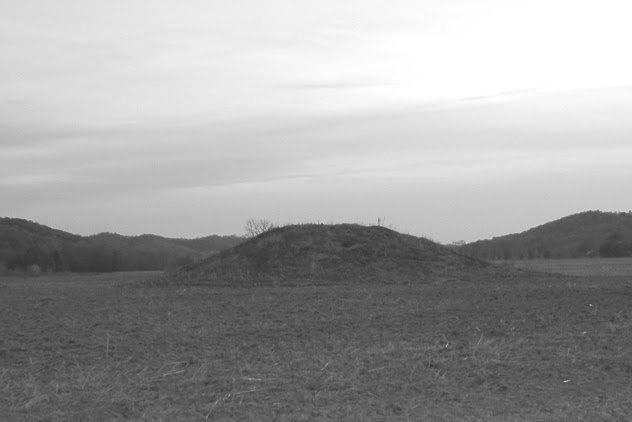
Another large mound was located east of the city of Chillicothe. The mound contained a skeleton over 8 feet in length. This is the mound before the Ohio Historical Society got their hands on it.

This is what the mound looks like today after being excavated by archaeologists

This large burial mound is located north of Mound City. Many large mounds, like this, are kept secret by the Ohio Historical Society so that if archaeologists want to destroy them, there will be a little public outcry.
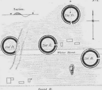 4 henges located in the city limits of Chillicothe, Ohio
 One of the hinges is still visible in this backyard overlooking Water Street


