Showing posts with label ancient. Show all posts

Wednesday, February 19, 2025

West Virginia's Massive Ancient Dams

 West Virginia's Massive Ancient Dams

More images and the full article in "Ancient America: The Dark Side"

“The ruins of the ancient stone dams, which are to be found in various places in Wyoming, McDowell, Boone, and Raleigh counties in West Virginia are at the present time attracting no small amount of attention from scientific archaeologists."

   “These dams in their original condition extended entirely across the valleys of the streams, from one hill to the other, and according to the very conservative estimates made by Col. J. R. Irwin were in many cases over 100 feet in height and 200 feet in width at their base. They are now in most cases covered up almost to their tops by alluvial accumulations, and the streams have worn passages down through them in many places almost to their very foundations, which is not to be wondered at when we consider their great age. “These dams are composed of very odd looking, wedge-shaped stones, the largest of which would weigh less than 100 pounds


Tuesday, September 17, 2024

Ancient California Tools and Artifacts Connections with the Ohio Valley

 Ancient California Tools and Artifacts Connections with the Ohio Valley

  The serpent mounds, earthworks, tool kits and the finding of giant human skeletons in northern California are identical to what is found in New York associated with the Point Peninsula Iroquois.

   Tool kits and burial practices on the west coast are identical to these found in the eastern Woodlands, that are associated with the Meadowood and Point Peninsula Iroquois Cultures. DNA studies have found a genetic link with the northwest coast's, Yakima Indians and the Ohio Hopewell. Were the Yakima a detached Iroquois tribeDaniel S. Meatte wrote in 1990 in Prehistory of the Western Snake River Basin“ Between 4,500 and 4,000 B.P., with possible extensions until 3,500 B.P. Identified cultural attributes include massive turkey-tail and cache blades, caches or obsidian blank/preforms, large side notched projectile points, flexed or semi-flexed inhumations, possible cremations, and candid skull interments. Additional characteristic include the use of red ochre. Human burials are placed in unmarked cemeteries with a preference for high sandy knolls along river terraces.”


Wednesday, August 28, 2024

Yellow Springs: Ohio's Haunted Blood Spring Necropolis.

 Yellow Springs: Ohio's Haunted Blood Spring Necropolis


    The mound builders constructed hundreds of burial mounds at this site.  Tales of disembodied voices at this haunted site are notorious. Blood Spring was a place where the living could commune with dead. 


A literal river of blood runs from this natural spring.  This would have been the Holy of Holies to the Mound Builders who interpreted Iron Oxides as the blood of the Earth Mother.


It is not known if the steps were constructed by the park employees or by the ancients.  A burial mound is located just beyond the top of the steps.


Springs were interrupted as a portal to the underworld.  The serpent was the consort of the Earth Mother in the underworld who acted as a protector of the dead.


Drinking from Blood Spring.  1000s of the ancients may have come to this site to drink and be cleansed by these waters.


Chunks of Red Ocher are found in great abundance around Blood Spring. It is very likely that much of the red ocher found in the Hopewell Sioux, burial mounds in the Ohio Valley came from this Holy site.


Behind Blood Spring is this Hopewell Sioux, burial mound.  It is left overgrown in the summer months and hard to see.  Park employees are clueless to the spiritual importance of this site.


Hundreds of small mounds once dotted the landscape around Blood Spring.  Antioch College destroyed many of the burial mounds.


A few yards from Blood Spring is this natural rock formation I've dubbed, "Skull Rock."


This is the spring that gives "Yellow Springs" it


Saturday, August 24, 2024

Ancient Indiana Travel: Six Ancient Sun Temples (Henges) in Indiana Dating 500 B.C.- 200 A.D.


Six Ancient Sun Temples (Henges) in Indiana Dating 500 B.C.- 200 A.D.

Ancient Indiana Travel

  There are eighty-five burial mounds and earthworks in Indiana! Only three sites are registered as historic sites or preserved. Most notable are the three henge complexes made to align with the sun, moon, and bright stars in New Castle, Cambridge City, and Mounds State Park in Anderson.
They date as early as 500 B.C - 200 A.D. The same people constructed the rectangular enclosure in Winchester to align with the solstices that created a Pythagorean triangle within the work. Indiana archaeologists reported this with another Pythagorean triangle formed in the spacing of the Newark, Ohio earthworks and recognized by Brad Lepper, curator of Archaeology at the Ohio History Connection. Near the Winchester work was another square earthwork at Fountain City that was constructed to be numerically harmonic with the lengths of the walls at Winchester. Winchester's east-west earthen walls were 1320 feet, and the north-south walls were 1080 feet. Fountain City consisted of four 780-foot walls. 1320 - 780 = 540, 540 + 540 = 1080.  Knowledge of pi, squaring circles, geometry, trigonometry, surveying...these people's math was as advanced as the rulers of Babylon from 2,000 B.C. - 1600 B.C. called the Amorites. They were one of the giant tribes accounted for in the Bible. 
    When you visit the earthworks, you will know that they are far more than piles of dirt.
    I believe the Amorites were the Adena mound builders. I think the Dakota Sioux were the Hopewell mound builders. The advanced mathematics used in constructing the geometric earthworks is not of Native American origin. Building henges as astronomical calendars are identical to those found in the British Isles with Amorite origins. In England, we have conical burial mounds surrounded by earthwork or moat, and we also find it is a type of burial mound in the Ohio Valley. There are too many similarities to suggest they are independent of one another. 
   Political correctness is the driving force behind the narrative of universities. Only recently have the universities acknowledged the Pythagorean triangles with the doctrine that if you believe the Native Americans didn't figure it out, it is deemed racist.

1.) Mounds State Park, Anderson, Indiana Burial Mound and Henge Complex
        There were ten henge groups in Indiana, Ohio, and Kentucky. The best preserved is Mounds State Park. The Great henge was constructed to align with the solstices and bright stars. The burial mound in the center of the henge's platform was aligned to the solstices for two thousand years before being destroyed by university archaeologists ignorant to its importance as a solar marker. Two earthworks are still visible but not marked by the park. 


The importance of the burial mound in the central platform is visible in this map of the henge's alignments. Universities destroyed the mound: they should rebuild it. The small work aligned to Fomalhaut is still visible but not marked. The outer wall has dips like a great serpent surrounding the central platform, these dips were made to align to stars and the solstices.

The importance of the burial mound in the central platform is visible in this map of the henge's alignments. Universities destroyed the mound: they should rebuild it.
   A henge is described as an earthwork with an interior ditch and an outer wall with a gateway that is generally aligned to a solar event. (This is an exception). The deep ditch initially held water.

To the north of the previous henge is this panduriform shaped henge that is aligned to the May 1 Beltane sunrise. The sun will also set on the gateway to the west on October 31.


2.) New Castle, Indiana Burial Mound and Henge Complex
 
    Despite Ball State University all but destroyed the jewel of Indiana's antiquities, which was the loaf-shaped burial mound surrounded by a deep ditch. Most of this burial is gone except for the ditch that surrounded it. There are still four henges visible, along with two burial mounds. This site is on public land but is not preserved or recognized as a historic site.
    
New Castle, Indiana henge complex.

You can only see the remnants of this mound and earthwork site in winter when the high grass has died. The ditch around the large mound is visible, along with the henge, a burial mound to the west. To the south, in the woods, three henges can be seen. 

This is the large loaf-shaped burial mound oriented to the east with a surrounding earthwork and ditch (much like a henge) before Ball State University archaeologists all but destroyed it. 


I am standing in the middle of the now-destroyed burial mound, looking west on the Equinox when the sun aligns with the two burial mounds. You can see the surrounding ditch in the foreground.

To the west of the loaf-shaped burial mound were two henges, one easier to see than the other. The outer walls of the henge are highlighted in the photo. One of the better-preserved henges is to the south.


Also, in New Castle, Indiana, this single henge has a gateway aligned to the winter solstice sunrise. The henge is located next to the High School in a public park.

Cambridge City, Indiana Henge Complex

    The Cambridge City Henge Complex has been plowed for a hundred years, yet the largest henge is still visible in cultivated fields. Originally, the southern henge was the same dimensions as the Mounds State Park henge at 210 feet in diameter. 
     It is hard to define, but the southern henge's gateway is a little north of east and may have been aligned to the May 1, Beltane sunrise. 
     One interesting feature at the site was a cut made in the earth to make a graded way that led from the center of the two henges to the creek below.
    Three major henge sites in Indiana, all within twenty miles of one another, make this the henge capital of the Ohio Valley. That only one is being preserved shows that Indiana needs to be made aware of the economic value of having these prehistoric remains utilized as travel destinations. 


The Indiana Geological Survey did this map of the Cambridge City works in about 1915. The original map shows that the southern henge was aligned to the east and the northern henge to what appears to be the summer solstice sunrise. Between the two henges you can see where the cut was made that lead down to the West Branch of the White River.

A LIDAR photograph of the site reveals that the southern henge may align with the May 1 Beltane sunrise. The Beltane alignment also occurs at the North Panduriform henge at Mounds State Park. The LIDAR image reveals that the northern henge was not circular in shape but a panduriform. The gateway appears to be aligned with the equinox sunrise. There are as many as thirteen smaller earthen circles at this site.

This photograph was taken on the cut's western side, looking east towards the earthworks. The sacred way connected the sun temples in the upper world to the water in the lower world. This geographical aspect also occurs at Mounds State Park and New Castle, where the burial mounds and henges were built on high bluffs overlooking a river. 

This is what the southern henge looks like today. It is still an impressive ancient sun temple.

Yorktown Indiana Henge

    A history of Delaware County mentioned in 1881 that near Yorktown, there was "one of those enclosures … of the class know as fortifications." I went to this site in or about 2006 and talked to the landowner, who complained that Ball State University archaeologists were trespassing on their land without even asking permission. They would have been given permission had they asked. Instead, they were asked not to return.
  Ball State archaeologists wrote in their report, "The site retains integrity and is one of only two surviving examples of isolated circular enclosures in east central Indiana."  Another isolated henge in Delaware County was destroyed by farming. A single henge still exists in New Castle, Indiana, and another in Allen County, Indiana.

Yorktown's henge gateway is aligned with the summer solstice sunrise. This is the first earthwork that the Archaeological Conservatory purchased." This is good since Indiana has no plans to preserve anything.

The interior ditch of the henge holds water as it was originally intended to do.

Fort Wayne, Indiana Henge


The henge is located north of Fort Wayne on the St. Joseph and is the northernmost of all the sun temples. I was at this site on the Equinox sunrise, and there was no alignment that I believed would line up on the Beltane sunrise of May 1.  Three other henges in Indiana and Ohio have this May 1 sunrise alignment that hints that a Celtic people once inhabited these regions.


Thursday, August 1, 2024

Noble County, Indiana's Ancient Fairy Mounds

 Noble County, Indiana's Ancient Fairy Mounds

Fairies and Ghosts witnessed at burial mound sites www.nephilimgiants.net : Fairies, Spirits and Ghosts at Burial Mound Sites

   Fairies have their origins in the Tuath De Danann of Ireland. When the giant Fomorians defeated them, they became fairies who dwelt in burial mounds and ditches of earthworks. They also have an affinity toward springs. 

   This spring in Noble County, Indiana, is the headwaters of the Elkhart River. Springs like this would have been venerated for their healing qualities. It is not believed that any burials are in these two mounds flanking each side of this spring. 

    Were these mounds constructed to be the dwellings of fairies or elementals? There are venerated springs associated with the Adena Hopewell mound builders in the Ohio Valley. This mound was also built by the Adena Hopewell, dating from 800 B.C. - 500 A.D.

   The mounds are on private property. Noble County has burial mounds that are visible from the road or on public land but has made no effort to preserve any of them. On the contrary, they have had two burial mounds partially destroyed by university archaeologists.


Monday, July 22, 2024

Ancient Adena (Celtic) Sun Temple Discovered in Chillicothe, Ohio


Ancient Adena (Celtic) Sun Temple Discovered in Chillicothe, Ohio


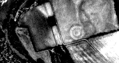
Adena mound builders sun temple is clearly visible on this aerial photo located outside of Chillicothe, Ohio    Many other earthworks were in Chillicothe, Ohio This is one of them  www.nephilimgiants.net : Hopeton Sacred Via was for the Procession of the Dead to Mound City


    The Ohio Historical Society and archaeologists have destroyed much of the Capital City of the Adena (Beaker People) and Hopewell (Sioux, Cherokee and Iroquois), but despite not being preserved, some of the most important sites can still be viewed.  Two large henges  were constructed on the confluence of Paint Creek and the North Fork of Paint Creek.  The two large henges are identical in size to the henges at Athens County, Ohio, Mounds State Park and Cambridge City, Indiana, which measured 660 feet in circumference.
    Henges, are circular earthworks with an outer wall and interior ditch and a gateway that is aligned to a solar event. Henges were adopted by the Beaker People, who also constructed Stonehenge.
    The archaeologist has called the Chillicothe burial mounds and earthwork Hopewell, but with this new find it shows that the capital city had a combination of both Adena and Hopewell elements and that it are the result of these two peoples merging into one society that is called the Adena-Hopewell.

Map of the Earthworks around Chillicothe, Ohio is originally drawn by Squire and Davis in Ancient Monuments of the Mississippi Valley 1846.  No description of the North Fork henge was given by Squire and Davis, nor has it shown up in any archaeological reports. 

This photograph from Google Earth clearly shows that the outer embankment of both earthworks is still visible in this plowed field. Why is this not being saved from the obliteration of the plow?


Thursday, June 20, 2024

Neanderthal Dwarf Cemetery Includes a Giant in Missouri


Neanderthal Dwarf Cemetery Includes a Giant in Missouri


The Cook County Herald, Oct. 24, 1903

Prehistoric Cemetery


     Workmen terracing King hill, an old landmark of the northwestern Missouri which is to be converted into a residential suburb of St. Joseph, have unearthed a prehistoric cemetery.  The remains of a race of dwarfs, not allied with any tribe known to have inhabited this territory, and unaccounted for by Indian legendary repose on the summit of King hill. A feature remarkable in itself and especially marked in connection with the dwarfish remnants of a prehistoric man found on the summit is the discovery of human bones, evidently those of a giant, probably more than seven feet tall and big boned.  Low flat heads with small intelligence and marked animal propensities, characterized this people.  Heavy jaws and strong, well-preserved teeth carry the records of their lives forward.  Brutes, human but not inhumane, self-reliant, they are savages of a lower order than are known today. Yet, they honored their dead.  Shells such as are found on the banks of many inland streams, plentiful on the sandbars of the Missouri, overlooked by King hill, and the stones of unusual hues, worthless in the commercial marts of today, the playthings of children, were deposited in the graves 


Saturday, May 18, 2024

Strange Ancient Picture Rocks Described in West Virginia


Strange Ancient Picture Rocks Described in West Virginia


The location of this stone is in the heart of the Adena mound builders.  The Native Americans were terrified of this region because they thought it was infested by evil spirits. Is this a depiction of what they encountered?

History of Kanawha County, W.V. 1876


   SCULPTURED STONES. About two and a half miles below the mouth of Paint creek, and twenty miles above Charleston, at the edge of the river, was a large flat stone, perhaps twenty feet square, called by the old settlers the "picture rock." It was embedded in the river, near the shore, and was not visible except during low water. It was literally covered with pictures of different animals, including turkeys, bears, deer, elk, fish, etc. ; and across the center of it was a large buffalo track cut deep in the stone. On the perpendicular face of the stone was the image of a man from the waist upwards; a little above, and to one side of the man, was a large bear — natural size — with his mouth wide open, in close proximity to the man's head. Two miles above this large sculptured stone was a smaller one, in which were engraved seven or eight tracks of a baby's foot, which were intended to represent the child as walking across the stone. A short distance above the village of Clifton, in the bed of the river, was still another stone, on which was neatly carved a large fish. Some person undertook to carry this stone away for the purpose of making a hearth, and broke it in twain; one piece, however, still remains in the river. These stones resembled the one that laid in the bottom of the river near the mouth of Campbell's creek, which will be described in another chapter. They were undoubtedly engraved by the same race of men, that unquestionably understood the art of sculpturing to a very considerable extent. The ruthless hand of the destroyer has relentlessly fallen upon all of these historic stones, and they have been quarried and removed for building purposes. It seems strange that men of intelligence would destroy such interesting relics of an ancient habitancy and civilization of the land in which they live
   About two and a half miles below the mouth of Paint creek, and twenty miles above Charleston, at the edge of the river, was a large flat stone, perhaps twenty feet square, called by the old settlers the "picture rock." It was embedded in the river, near the shore, and was not visible except during low water. It was literally covered with pictures of different animals, including turkeys, bears, deer, elk, fish, etc. ; and across the center of it was a large buffalo track cut deep in the stone. On the perpendicular face of the stone was the image of a man from the waist upwards; a little above, and to one side of the man, was a large bear — natural size — with his mouth wide open, in close proximity to the man's head. Two miles above this large sculptured stone was a smaller one, on


Sunday, May 12, 2024

Photographs of the Remains of the Ancient North Fork Earthwork in Ross County, Ohio

 Photographs of the Remains of the Ancient North Fork Earthwork in Ross County, Ohio

North Fork Works in Ross County, Ohio

There is little visible of this once impressive ancient Hopewell earthwork and burial mound site near Chillicothe, Ohio, in Ross County, Ohio. The DNR has turned it into a public park, spending money on a parking lot and bathrooms, but has yet to do anything to restore the earthwork. There are also no signs to direct visitors to the small sections where the original earthwork is still visible.

You can find these spots by going north up the hill. The remaining portion of the earthwork is in the right corner of the map, where it goes up the hill and then turns and parallels the top of the hill. The earthwork can be traced for a short distance at the top of the hill. The best place to see the ditch on the embankment's north side is a little further down to the west.  There are also some remnants of the work on the extreme western side of the hill, where the embankment went back down towards the lower area.

In the lower area are a few Swails on the ground, which was once the site of the longest burial mound in the Ohio Valley.


This is the corner of the earthwork at the top of the hill. The earthwork can be traced a short distance down the hill. From this spot, the square earthwork would have been at the bottom of the hill.


To the west of the corner embankment the ditch that was outside of the earthwork can be traced for a short distance. The best (only) time to investigate these ancient sites is in the winter.